GLOBAL TERRESTRIAL NETWORK (GTN) GRID CELLS OF 160x160 km
Files for downloading:
-
IUGS-CGGB_19833_GRN_160x160km_grid_cells.xlsx (Microsoft Excel file containing the grid cells that cover the whole globe - land and sea)
-
IUGS-CGGB_19833_GRN_160160km_grid_cells.zip (The same as above but a Google Earth *.kml file in zip format)
-
IUGS-CGGB_7356_GTN_160x160km_grid_cells.xlsx (Microsoft Excel file containing the grid cells that cover the terrestrial part of our planet)
-
IUGS-CGGB_7356_GTN_grid_cells_160x160km.zip (The same as above but a Google Earth *.kml file in zip format)
========================================================================================
History of development of the Global or Geochemical Terrestrial Network (GTN)
The original Global Terrestrial Network or Geochemical Terrestrial Network (GTN) of 160 x 160 km grid cells covered the terrestrial part of our home planet Earth with 5700 grid cells. However, coastal parts where the centre of the 160x160 km grid cell fell in water (ocean, sea, lake) were deleted from the database, and this action also affected most islands. The problem was discovered during the planning of the FOREGS Geochemical Atlas of Europe project (1997), and at the time it was corrected only for the European part. As more countries are interested in participating in the Global Geochemical Baselines project, it was important to correct this problem of missing coastal and island grid cells. Robert G. Garrett (Geological Survey of Canada) provided the original file of the Global Reference Network grid cells of 160x160 km covering the whole globe (August 2018), which was generated in 1994 by Nils Gustavsson (Geological Survey of Finland), and consisted of 19,833 grid cells of 160x160 km. Alecos Demetriades (Hellenic Institute of Geology and Mineral Exploration, and Chairperson of Sampling Committee) superimposed the two files of 5700 and 19,833 grid cells, and located all missing grid cells, and a new GTN grid cells database was generated with 7356 grid cells of 160x160 km (August-September 2018).
Xiaoyuan Geng and Juanxia He (Canadian Soil Information Service, Science and Technology Branch, Agriculture and Agri-Food Canada, http://sis.agr.gc.ca/) have undertaken the task to generate the 5 and 8 random points within each GTN grid cell of 160 x 160 km (September to November 2018) - see Sampling Design web page. The reason for generating two different files, with 5 and 8 random points in each 160x160 km grid cell, is that these two options are given in the ''The Blue Book'' (Darnley et al., 1995), and countries are free to select which sampling density will be using. In the FOREGS Geochemical Atlas of Europe project, the 5 random site option was selected as is more cost-effective. For the sake of history, the files of 5 random sites in each GTN grid cell for the 26 European countries, which participated in the FOREGS Geochemical Atlas of Europe project, were provided by the Geological Survey of Finland (Timo Tarvainen).
The new database of 7356 grid cells of 160x160 km, and the 5 and 8 random points within each GTN grid cell of 160x160 km are provided in a Microsoft Excel Workbook for the planning of the Global Geochemical Baselines project in each country (see Sampling Design webpage). In addition, the original file of the Global Reference Network of 19,833 grid cells of 160x160 km, and Google Earth *.kml files are provided for reference purposes, and future use in case sampling is extended in the seas and oceans.
Besides the generation of databases for 5 and 8 random points within each GTN grid cell of 160x160 km, it was decided during the October 2018 meeting of the Scientific Committee of the UNESCO International Centre on Global-Scale Geochemistry to generate another database for 16 random points within each GTN grid cell of 160x160 km. However, this is not a recommended sampling design for the Global or Geochemical Reference Network project. It is only for countries wishing to carry out a wide-spaced geochemical survey at a higher sampling density using a random design.
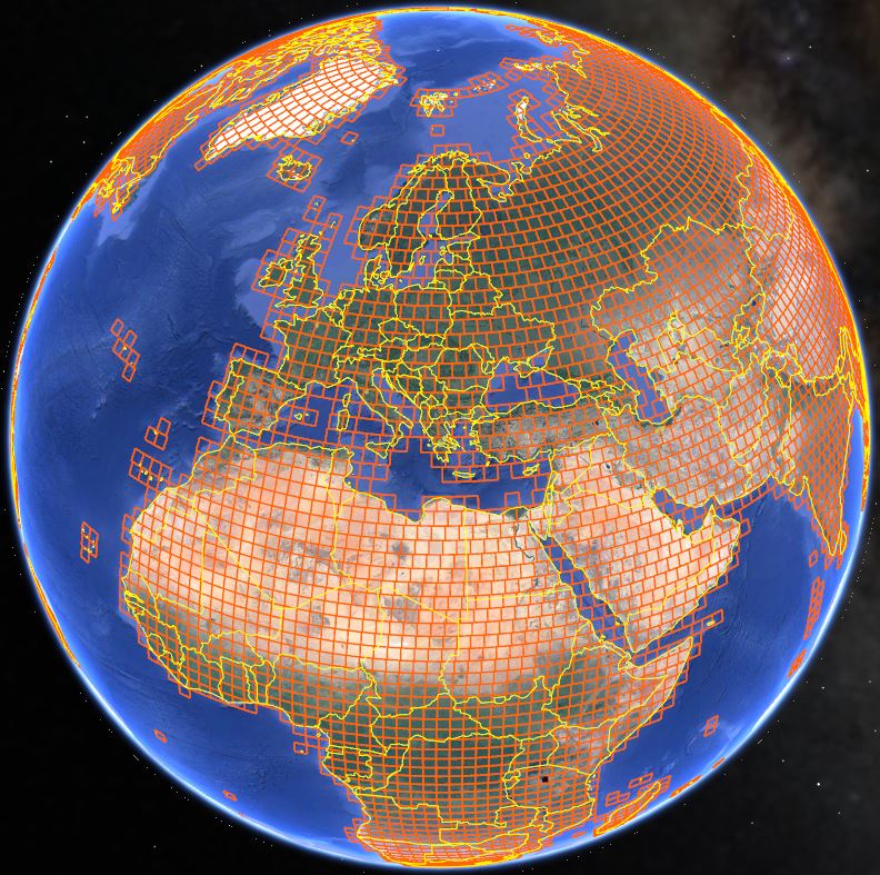
Below is a Google Earth image showing the GTN grid cells of 160 x 160 km covering Europe, Asia, Africa, Greenland and part of Canada.