BACKGROUND
There is worldwide concern about the potentially damaging effects of chemicals in the environment on the health of humans, animals, agriculture and ecosystems. Economic and population growth are increasing rapidly, exacerbating such problems as land degradation and pollution from uncontrolled urbanisation, industrialisation, intensive agricultural practices and over-exploitation of aquifers. These and other problems are having an impact on the geochemistry of the Earth's surface and the sustainability of its life-support systems from the local to the global scale.
Defining and understanding the current abundance and spatial distribution of chemicals in different environmental compartments (e.g., soils, sediments, surface and ground water, vegetation) are essential first steps in being able to recognise and quantify natural or human-induced changes in the future. Dr. Mary Lou Zoback, former President of the Geological Society of America, stated the issue eloquently: ''Documenting and understanding natural variability is a vexing topic in almost every environmental problem: How do we recognise and understand changes in natural systems if we don't understand the range of baseline levels'' (Zoback, M. L., 2001. Grand Challenges in Earth and Environmental Sciences - Science, Stewardship, and Service for the Twenty-First Century: Geological Society of America Today, v. 11, no. 12, pp. 41-47. URL: http://www.geosociety.org/gsatoday/archive/11/12/pdf/i1052-5173-11-12-41.pdf).
Systematic geochemical mapping is the best method available to assess and provide a basis for monitoring changes in the levels of chemical elements at the Eart's surface. Geochemical maps have traditionally been valuable in addressing a whole range of environmental problems, as well as for identifying potential mineral resources at the local to national scale. Several decades of geochemical mapping by national geological surveys, and related organisations throughout the world, have resulted in a wealth of valuable information. However, these data cannot readily be applied to broader regional or global studies, because they have been collected using different sampling, analytical and data interpretation methods (Darnley et al., 1995 - ''The Blue Book''). Part of the reason behind this is that there are no internationally agreed standards for geochemical surveys.
Such incompatible data could be used if they were normalised to a reference dataset, i.e., data generated from a worldwide suite of geochemical samples collected, prepared, analysed and interpreted using a universally consistent set of protocols. Each of the available geochemical survey datasets could then be normalised to the reference dataset and interpreted across political boundaries in order to identify geochemical features, including both enrichment and depletion of elements, with the potential to affect the health of humans, animals and ecosystems. New areas with potential for undiscovered mineral resources could also be identified.
HISTORY AND OBJECTIVES
The Commission on 'Global Geochemical Baselines' has the long-term goal of establishing a global geochemical database to document the concentration and distribution of chemical elements and species in the Earth's near-surface environment. The database and accompanying element distribution maps can then be used to establish a geochemical baseline against which future human-induced or natural changes to the chemistry of the land surface may be recognised and measured.
The current Commission traces its origins to 1988 as Project 259 'International Geochemical Mapping' of UNESCO's International Geological Correlation Programme (IGCP), now known as the International Geoscience Programme. IGCP is a cooperative enterprise of the United Nations Educational, Scientific and Cultural Organisation (UNESCO) and IUGS. This first phase was concluded with the publication of UNESCO Report 19 'A global geochemical database for environmental and resource management' (Darnley et al., 1995 - 'The Blue Book'). This detailed the requirements necessary for establishing a global geochemical database through multi-media, low-density sampling on the basis of the Global Terrestrial Network (GTN) (see Figure 1), which covers the Earth's land surface with about 5000 grid cells of 160 × 160 km (area 25 600 km2). These requirements included:
- commonly available representative sample media, collected in a standardised manner;
- continuity of data across different landscape types;
- adequate quantities of the sample media for future reference and research requirements;
- analytical data for all elements of environmental or economic significance;
- the lowest possible detection limits for all elements; and
- strict quality control at every stage of the process.
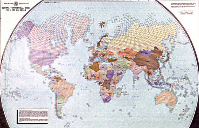
Figure 1. Map showing the Global Terrestrial Network of 160x160 km grid cells.
From 1993 to 1997, the project continued under the IGCP as Project 360: 'Global Geochemical Baselines'. The design of the GTN was finalised and sampling sites selected in a statistically random way, based on the 160×160 km grid system. Standardised methods for geochemical sampling, sample preparation, analysis and data management to be used in conducting the global-scale geochemical survey, agreed by the representatives of more than 100 countries, were also prepared during this phase of the project. More detailed methods for sampling in semi-arid, temperate and glaciated terrains were published in the "FOREGS/EuroGeoSurveys Geochemical Mapping Field Manual" (Salminen et al., 1998), which can be downloaded from URL http://tupa.gtk.fi/julkaisu/opas/op_047.pdf.
Following completion of the two IGCP projects, the International Union of Geological Sciences (IUGS), in collaboration with the International Association of GeoChemistry (IAGC), established in 1998 the current Task Group on 'Global Geochemical Baselines'. The Task Group's main objective for this phase has been to encourage and facilitate the population of the GTN worldwide through application of the sampling, sample preparation, analytical and data management protocols established in the earlier phases of the project. This has been achieved by making the expertise within the Task Group available to countries interested in initiating a national geochemical survey.
Following the UNESCO decision on the 13th of November 2013 at its 37th session in Paris to establish the International Centre on Global-Scale Geochemistry in Langfang, P.R. China (http://www.globalgeochemistry.com/), the officers of the IUGS Executive Committee at their 68th sitting on the 28 January 2015 in Vancouver, Canada, judged positively the proposal for the establishment of an IUGS Commission on Global Geochemical Baselines (see Minutes: http://iugs.org/uploads/Final%20version%20of%20the%20Minutes%20of%2068th%20EC%20Meeting%20-%20Vancouver%202014.pdf).
According to the minutes of the 68th IUGS Executive Committee meeting:
- The Commission can run in parallel with the establishment of a Subcommission/Working Group on Isotopes taking advantage of the now existing isotope group (TGIG).
- The establishment and design of the new Commission is compatible and should be synergic with the IUGS Resourcing Future Generations Initiative.
- Also in terms of synergy with the current activities of IUGS, it seems crucial and quite suitable that One Geology serves as visualisation platform for the new geochemical data base.
- Global Geochemical Baselines would be a suitable project proposal for the ICSU's Future Earth Initiative.
The upgrading of the Task Group to Commission was again discussed at the 69th meeting of the Executive Committee in January 2016.
On the 31st of August 2016 at the Fourth Ordinary Session of the IUGS Council Meeting in Cape Town the establishment of an IUGS Commission on Global Geochemical Baselines was approved.
Summary of project phases
Phase I: IGCP 259 (1988-1992). Reviewed the regional geochemical activities world wide, assessed the requirements and methods for global geochemical mapping, and recommended sampling, sample preparation and analysis, and data management methodologies for the development of a global geochemical database. The final report 'A global geochemical database for environmental and resource management', A.G. Darnley et al. (1995) was published by UNESCO, Earth Sciences Publication 19, and is known as the 'Blue Book', because of its cover. During this period extensive research work was carried out in Europe, China and Canada especially for the development of continental scale geochemical mapping techniques. During this period the Geochemistry Group of the Western European Geological Surveys carried out extensive research in Europe for the use of overbank or floodplain sediments as a medium for continental scale mapping (Ottesen et al., 1989; Bølviken et al., 1990, 1993, 1996; Demetriades et al., 1990; Swennen et al., 1994; De Vos et al., 1996; Hindel et al., 1996).
Phase II: IGCP 360 (1992-1997). Established a worldwide network of professional applied geochemists. Developed a set of methods for GRN sampling in temperate, glacial and mediterranean climates. Initiated discussion of methods for sampling in other climates. Published the first version of the 'FOREGS geochemical mapping field manual' (Salminen, Tarvainen et al., 1998), which is currently being updated to include sampling instructions in other morphoclimatic terrains, such as karst, desert, tropical, tundra and arctic. During this phase the suitability of overbank or floodplain sediments as a global sampling medium was tested in China (Xie and Cheng, 1997; Xie et al., 1997).
Phase III: IUGS/IAGC Task Group on 'Global Geochemical Baselines' (1997 - 2016). During this phase 26 European countries participated from 1996 to 2006 in a common project under the auspices of the Forum of European Geological Surveys (FOREGS), presently the Association of European Geological Surveys (EuroGeoSurveys or EGS: http://www.eurogeosurveys.org/). The results of this project have been published in two printed volumes, which are both freely available for downloading from URL: http://weppi.gtk.fi/publ/foregsatlas/:
(1) Salminen, R., Batista, M.J., Bidovec, M., Demetriades, A., De Vivo, B., De Vos, W., Duris, M., Gilucis, A., Gregorauskiene, V., Halamic, J., Heitzmann, P., Lima, A., Jordan, G., Klaver, G., Klein, P., Lis, J., Locutura, J., Marsina, K., Mazreku, A., O' Connor, P.J., Olsson, S.Å., Ottesen, R.T., Petersell, V., Plant, J.A., Reeder, S., Salpeteur, I., Sandström, H., Siewers, U., Steenfelt, A. & Tarvainen, T., 2005. FOREGS Geochemical Atlas of Europe, Part 1: Background Information, Methodology and Maps. Geological Survey of Finland, Espoo, 526 pp.
(2) De Vos, W., Tarvainen, T. Salminen, R., Reeder, S., De Vivo, B., Demetriades, A., Pirc, S., Batista, M.J., Marsina, K., Ottesen, R.T., O?Connor, P.J., Bidovec, M., Lima, A., Siewers, U., Smith, B., Taylor, H., Shaw, R., Salpeteur, I., Gregorauskiene, V., Halamic, J., Slaninka, I., Lax, K., Gravesen, P., Birke, M., Breward, N., Ander, E.L., Jordan, G., Duris, M., Klein, P., Locutura, J., Bel-lan, A., Pasieczna, A., Lis, J., Mazreku, A., Gilucis, A., Heitzmann, P., Klaver, G. & Petersell, V., 2006. Geochemical Atlas of Europe. Part 2: Interpretation of Geochemical Maps, Additional Tables, Figures, Maps, and Related Publications. Geological Survey of Finland, Espoo, 692 pp.
In addition to the geochemical mapping programme in Europe, other continental-scale projects, which do not fulfill the standards for the global geochemical baselines database, but are important for national or continental use, have also been carried out in Australia (National Geochemical Survey of Australia, 2006-2011), China (China Geochemical Baselines project, 2008-), India, Nigeria, Mexico and the United States of America (North American Soil Geochemical Landscapes Project; https://pubs.usgs.gov/
Phase IV: The IUGS/IAGC Task Group on Global Geochemical Baselines has been elevated to an IUGS Commission in 2016 with the mandate to set the standards for the Global Geochemical Baselines project. This IUGS mandate is included in the statutes of the UNESCO International Centre on Global-Scale Geochemistry, which were approved and ratified by the Centre's Governing Board at its siting on the 16th of October 2018, and these are:


